
|
The Modern Antiquarian Forum » WHAT IS IT ? (in Northumberland) |
Log In to post a reply
|
|
|
|
| Topic View: Flat | Threaded | |
|
Aspinall 40 posts |
Jul 03, 2002, 20:18
|
||
|
"I was on my way to see your father," he said at length. "This morning I have prospected the barrow of Harald Blacktooth, and it is clear to me that I can make no progress unless I have Colonel Raden's permission to use explosives. Only the very slightest use, I promise you. I have located, I think, the ceremonial entrance, but it is heavily blocked with boulders which it would take a gang of navvies to raise with crowbars. A discreet application of dynamite would do the work in half an hour. I cannot think that Colonel Raden would object to my using it when I encounter such obstacles. I assure you it will not spoil the look of the barrow." "I'm sure papa will be delighted. You're certain the noise won't frighten the deer? You know the Piper's Ring is in the forest." "Not in the least, my dear young lady. The reports will be very slight, scarcely loudly than a rifle-shot." from John Buchan's JOHN MACNAB (1925) Penguin Books
|
|||
|
Aspinall 40 posts |
Jul 05, 2002, 06:34
|
||
|
Here's the listing from the county SMR - Name of Resource: Earthwork 400m NW of Low Thornhope Description: Embankment containing large boulders, running roughly parallel with old railway line Project Date(s): Bibliographic references: Pers Comm, P F Ryder, 1987 Record Maintainers: Conservation Team, Northumberland County Council, Morpeth (Contact Mrs E. Williams) Map reference: NY 680 514 Place: Earthwork 400m NW of Low Thornhope County: Northumberland Parish: KNARESDALE WITH KIRKHAUGH District/ Unitary Authority: Tynedale Country: England Period: UNKNOWN Subject: EARTHWORK Subject: LINEAR EARTHWORK Resource Identifiers use when citing resource Depositors ID: NY 65 SE 20 Record last checked: 12 September 2000 Record Copyright © the Record Maintainers. + Name = Thornhenge Type of monument = not known Length of monument = 400m. (e) Number of stones = not known Mass of stones = not known Associated features = pair of excavated tumuli, altered drumlin, burial cairns, copper mine (Bold Venture), silver mine (Tynebottom), cup-marked rocks, standing stones, boulder tomb "I'll offer the excellent Badly Drawn Boy 'About A Boy' soundtrack CD to the first person to correctly identify this monument. If it's 'big' - a Bronze Age palace or a foundry - then I'll upgrade that to a signed copy of the CD ! My own guess is 'cursus monument' - there must be over two hundred stones there and when I first saw it I couldn't stop swearing, over and over again - I've just never seen anything like it - so 'curses' became 'cursus'(I'm not an archaeologist). The name I gave it >is< appropriate (Spinal Tap are inspirational and, in my eyes, St. Clair, Tuffnell and Smalls can do no wrong !) Good luck - and may the best person win !" David
|
|||
juamei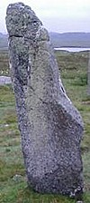 2013 posts |
Jul 05, 2002, 10:24
|
||
|
A very long longbarrow?? As far as I know a cursus is 2 parrallel banks, with external ditches and a closed end. Kinda like a giant U shape. Have you got any pictures? sounds fantastic...
|
|||
fitzcoraldo 2709 posts |
Jul 05, 2002, 20:25
|
||
|
It's a linear earthworks of course..doh! Sorry m8 I can't identify your whatsit there are roman remains close by according to ARCHI; roman bridge castle at NY 700 492 roman bridge abutment NY 699 493 roman fort NY 695 487 loads of mines about too. Looks like a fascinating area happy hunting fitz
|
|||
|
BrigantesNation 1733 posts |
Jul 09, 2002, 00:44
|
||
|
Sorry I've not made it up there yet. I may have found something similar. I visited an Iron age hill fort and settlement close to Ripon a couple of days ago, part of it was a levelled entrance track which travelled about a hundred metres to a stream below. Along its outer edge there seem to have been standing stones, I'd estimate about twenty or so originally. Any chance of a description of the dimensions of the earthwork itself and the stones?
|
|||
|
Aspinall 40 posts |
Jul 09, 2002, 07:21
|
||
|
It seems recti-linear, with rounded corners. There are two, discontinuous, lines of stone that are not geometrically straight and also there are outlying standing stones, most of which have been pushed over. The lines of stone seem to wander. The farmer is middle-aged and quite kindly. Called Mr Raine - he doesn't mind it being called Thornhenge ! He's always assumed that it was the old road to Alston. There are ditches that still seem quite deep. One has become the course of a stream. The two fields that the monument is (mainly) in are full of rushes that hide it almost completely. Among my cup-marked rocks, a mile and a half away, I've found a Boulder Tomb (I think). The capstone is certainly covered with simple cup-marks. If I offer to donate that, as it is, to the local natural history museum (donatee to collect) then, maybe, I may be able to persuade the County Archaeologist's office to get a council team out to strim the two fields. It was an under-contract-to-them archaeologist surveying, I think, late-period Bastle houses (or it may have been field lime kilns) that originally listed this monument on the SMR. Next we need the RAF to change some of their practise low-level bombing runs to reconnaisance flights. Half metre resolution infra-red images would be extremely useful. There is someone to ask (but we've fallen out badly)... About a mile away, broadly to the south, is the associated - I assume - ceremonial site. This looks like a destroyed stone circle (plus other bits). It's mainly in one field and is an X-rated horror. It's possibly useful to show the historic methods of stone circle destruction - unfortunately. There are several horizon markers intact, luckily, and a deep notch formed by two hills to the north west - an autumn sunset alignment probably. I'd love to put some of these stones back up - but it's even impossible to know which way up they were set originally. And it's such a jumble. (The farmer is ok here too.) An outlying stone may be 'drilled' and, among a pile of five or six massive stones, is one with two deep fissures, one with a stone chip wedge driven in. (I only had ten minutes and my film was gone.) These stones are 'contiguous' in style and size with Long Meg, Mayburgh, Glassonby, Grey Yauds, Broom Rigg, and Featherstone. The map reference for this eliminated stone circle is NY701487. Suggestions of a name for it to the usual place (here). It's overlooked by a Roman fort, Epiacum, and there is, what looks like, the substantial remains of a Viking-period stone house, in the next field, beside Gilderdale Burn and the 1852 railway viaduct. I may make a rudimentary press release, about Thornhenge, and will post it here. I'd like What-Is-It to act as a kind of smokescreen for these cup-marked rocks nearby - which are fragile - there'll be more. I guess the person that deciphers the site can name it - isn't that the convention ? It's not a henge and there's not many thorns left either ! Thanks ! David
|
|||
|
Aspinall 40 posts |
Jul 21, 2002, 09:28
|
||
Here's the first picture - ( http://www.megalithic.co.uk/modules.php?op=modload&name=My_eGallery&file=index&do=showpic&pid=1551&orderby=dateD ).
|
|||
|
caergog 393 posts |
Jul 21, 2002, 15:17
|
||
|
sorry to interupt did you get my e-mail re-craig phadrig? love carolinexx
|
|||
|
BrigantesNation 1733 posts |
Jul 22, 2002, 09:31
|
||
Yes I did, very interesting, I need to get a copy of that book.
|
|||
|
caergog 393 posts |
Jul 22, 2002, 18:39
|
||
|
as i mentioned alot of it may be irrelevant to you due to the folklore and hisroical aspects of inverness. My dad hasn't sent it yet but i would be happy to copy the relevant chapter for you and save you a few quid! love carolinexx
|
| Pages: 3 – [ 1 2 3 | Next ] | Add a reply to this topic |
|
|
|
| The Modern Antiquarian Forum Index | |