
|
The Modern Antiquarian Forum » Silbury Hill » Map or plan of Silbury hill area |
Log In to post a reply
|
|
|
|
|
|
Topic View: Flat | Threaded |
|
AnnaDevon 9 posts |
Jun 15, 2009, 09:52
|
||
|
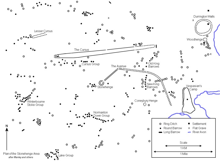
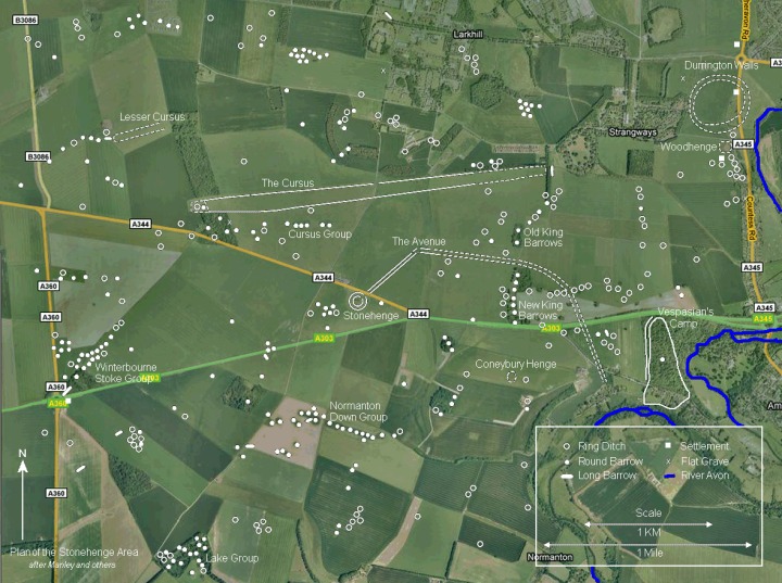
Hello all, I was watching the repeat on BBC4 last night about Silbury hill and it's surroundings, Avebury stone circle, the 2 avenues, the Sanctuary and west kennet long barrow which I really enjoyed. Does anyone have a map or plan that includes all of the above mentioned places? Someone very kindly posted a map and plan of the Stonehenge area and it really helped me to put things into perspective and was hoping to do the same with the Silbury hill area. I will include them in case anyone has not seen them before. http://www.themodernantiquarian.com/img_fullsize/72943.jpg http://www.themodernantiquarian.com/img_fullsize/72944.jpg
|
|||
|
megadread 1202 posts |
Edited Jun 15, 2009, 15:05
Jun 15, 2009, 13:23
|
||
|
Take a look at this site, it should have everything you need. http://www.avebury-web.co.uk/index.html Direct link to a map - http://www.avebury-web.co.uk/avebury_map.html there's also an interactive map here but it doesn't seem to work right for me. http://documents.kennet.gov.uk/avebury/aveburyvirtual/main_map/main_map_monuments.htm
|
|||
|
AnnaDevon 9 posts |
Jun 15, 2009, 21:02
|
||
|
Fantastic, thanks that is just what I was looking for. I have visited Avebury and Silbury hill a couple of times before but I was unaware of all the other nearby features at the time. So if I park near Avebury and walk down the West Kennet Avenue will it lead me all the way to the Sanctuary or have some of the stones long since disappeared? On the map I see that if all the Avenue still existed I would need to cross the B4003 and then the A4 to get to the Sanctuary.
|
|||
|
megadread 1202 posts |
Jun 15, 2009, 21:38
|
||
|
It's not a continuous avenue any more Anna and i'm pretty sure there is no path to follow the avenue the whole length, i follow the road where the Avenue peters out till the A4 then walk the rest of the way to the sanctuary along the A4. Theres only a rudimentary grass verge to follow some of the way till you get to the A4 too so wet feet are the norm. I'm gonna be down there from friday till at least tuesday and will be visiting all the sites numerous times, you could tag on with us if you want. My email is - [email protected] message me if you want.
|
|||
|
tonyh 247 posts |
Jun 16, 2009, 20:59
|
||
|
Next year.. Tony
|
|||
|
AnnaDevon 9 posts |
Jun 18, 2009, 10:39
|
||
|
megadread wrote: It's not a continuous avenue any more Anna and i'm pretty sure there is no path to follow the avenue the whole length, i follow the road where the Avenue peters out till the A4 then walk the rest of the way to the sanctuary along the A4. Theres only a rudimentary grass verge to follow some of the way till you get to the A4 too so wet feet are the norm. I'm gonna be down there from friday till at least tuesday and will be visiting all the sites numerous times, you could tag on with us if you want. My email is - [email protected] message me if you want. Yes I can see by the plan you linked me to that I should have no problem finding the Sanctuary by following the A4. I understand the "Area of the Enclosures" is on private land so I wont be allowed on there unfortunately but will walk to the WKLB, Silbury Hill and then up the Beckhampton avenue back to Avebury. Thanks for the offer to tag along but I have already made arrangements for this weekend. Hope you all have a wonderful time.
|
|||
Pete G 3506 posts |
Jun 18, 2009, 20:52
|
||
|
the Enclosure site is now open access land, just don't walk through crops. the farmer set aside a strip by the hedgerows which is accessable from the path, PeteG
|
|||
|
AnnaDevon 9 posts |
Jun 19, 2009, 09:55
|
||
|
Thanks for letting me know that Pete, it would have been a shame to walk past it thinking it was not accessable. I will stick to the strip by the hedgerows. Is it possible for me to walk past Silbury Hill along the A4 and walk back to Avebury along the Beckhamptom Avenue? If so would I need to walk as far as the roundabout where the A4 and the A361 meet?
|
|||
|
Pete G 3506 posts |
Jun 19, 2009, 11:36
|
||
|
there is no path between the Silbury car park and the Waggon & Horses so be careful on that busy road. You can visit the Adam & Eve stones but the rest of the avenue is buried and under crop. You can walk to Avebury through Trusloe via South st, Pete
|
| The Modern Antiquarian Forum Index |