
|
The Modern Antiquarian Forum » Lincolnshire and Humberside » immingham blue stone |
Log In to post a reply
|
|
|
|
| Topic View: Flat | Threaded | |
|
darkman 5 posts |
Mar 07, 2012, 17:16
|
||
does any one on here have any info of this standing stone , its always been at the end of bluestone lane , now out side a pub of the same name will post a pic up as soon as i can
|
|||
|
Rhiannon 5291 posts |
Mar 07, 2012, 23:05
|
||
|
I don't know anything about it I admit, but there's a photo here in the meantime http://www.geograph.org.uk/photo/1389547 I was looking at some old maps and it's marked on one from the sixties (when the pub is there) but not from the 30s or before. Do you think it could have got dug up when they changed the road / built the pub? And then they named the road after it (when they built all the houses along it)? Perhaps they'd know something in the local museum or library? Or even in the pub!
|
|||
thesweetcheat 6214 posts |
Mar 07, 2012, 23:09
|
||
|
Rhiannon wrote: Perhaps they'd know something in the local museum or library? Or even in the pub! I like the way this research trip is shaping up.
|
|||
Sanctuary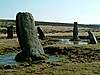 4670 posts |
Mar 07, 2012, 23:28
|
||
|
thesweetcheat wrote: Rhiannon wrote: Perhaps they'd know something in the local museum or library? Or even in the pub! I like the way this research trip is shaping up. Especially if beer prices still match the age of the stone!!!
|
|||
|
sammie 36 posts |
Mar 08, 2012, 10:25
|
||
It looks so sad being used as a statue. Please do the research and try to get it back to where it belongs.
|
|||
|
darkman 5 posts |
Mar 08, 2012, 11:08
|
||
|
thanks for replys and photos i couldnt find how to up load one ,i live near by this place and yes its very sad stone, so dont think thats its original place , and a few years ago they ( the pub) decided to paint it red and white for england match ) looking into more if its history and where it came from , i know of The town, Immingham, has a completely English name which is unusual in an area noted for large-scale Norse settlements. This suggests that the name of the town dates from before the Viking invasion of this area. Bede mentions a Northumbrian nobleman called Imma,
|
|||
|
Chris Collyer 849 posts |
Mar 08, 2012, 13:53
|
||
|
There are a few similar stones dotted around northeast Lincolnshire but I hadn'd come across the Immingham one before. There another picture of it here - http://www.flickr.com/photos/thedouglascampbellshow/2985072803/in/set-72157608391975010/ Information about the stones is thin on the ground but they seem to be regarded as glacial erratics and as large boulders are so rare in the area they have ended up with names and legends attached to them, mostly to do with the Danes. Quite a few of them seem to have moved around over the years too. This page has three stones - http://homepage.ntlworld.com/nigel.portas/legend1.htm There are a couple of stones outside Louth museum - http://g.co/maps/5ew9r The 'Sons of TC Lethbridge' website used to have a page about some of these stones but the site doesn't seem to be working properly at the moment. I think the link was this one- http://tc-lethbridge.co.uk/tekhs_journal/?id=131 -Chris
|
|||
|
darkman 5 posts |
Mar 08, 2012, 15:50
|
||
|
thanks chris , also found this in humberston could be linked to all the other stones in the area and maybe linked to humberstone in leicestershire http://www.grimsbyandcleethorpes.co.uk/copyright/humberstone.jpg
|
|||
|
thesweetcheat 6214 posts |
Mar 09, 2012, 22:20
|
||
|
Rhiannon wrote: I was looking at some old maps and it's marked on one from the sixties (when the pub is there) but not from the 30s or before. Do you think it could have got dug up when they changed the road / built the pub? And then they named the road after it (when they built all the houses along it)? On the 25" maps from the 19th century, there's a "guide post" shown in the centre of the junction. That stays in place until relatively recently, but as Rhiannon says, the "stone" isn't shown until the 60s. I did wonder if the "guide post" and "stone" were the same thing, like the "Guide Post" marked on the current OS map at Teddington Cross Hands near Cheltenham, that is in fact the Tibble Stone. But it's not, because the 60s map shows both "stone" and the guide post (as "GP"). It's a mystery.
|
|||
|
thesweetcheat 6214 posts |
Mar 09, 2012, 23:05
|
||
|
http://webcache.googleusercontent.com/search?hl=en&safe=off&rls=com.microsoft%3Aen-gb%3AIE-SearchBox&rlz=1I7DKUK_en&q=cache:ZX2KC1PelC0J:http://cluster.biodiversitylibrary.org/n/naturalhistoryof00woodrich/naturalhistoryof00woodrich_djvu.txt+parish+records+bluestone+immingham&ct=clnk Scroll a long way down, to find this: THE LINCOLNSHIRE BOULDER COMMITTEE. A COMMITTEE has been appointed by the L. N. U. for the purpose of recording all the facts they can collect concerning the erratics left by the great ice sheet that once overspread the county. It consists of the following members : F. M. Burton, F.G.S. ; J. H. Cooke, B.Sc., F.G.S. ; H. Preston, F.G.S. ; A. W. Rowe, F.G.S. ; Percy F. Kendall, F.G.S. ; E. A. Woodruffe-Peacock, F.G.S. ; and W. Tuckwell. They wish that the following directions should be read over and acted upon in reporting to the Committee's Secretary. Shortly, in case of haste, the following points should be noted : I. Dimensions of Boulder in length, breadth, height above Sound, f what material composed ; Blue-Stone, Red Granite, Grey Granite, Sandstone. 3. Rounded or angular, smooth or scratched. More fully, the following : (A} ISOLATED BOULDERS. i. What is the name of the Parish, Estate, and Farm on which Boulder is situated, adding nearest Town, and County, and any particular enabling its position to be marked on the Ordnance map ? 2. What are dimensions of Boulder, in length, breadth, and height, above ground ? 3. Is the Boulder rounded, subangular, or angular ? 4. If the Boulder is long-shaped, and has not been moved by man, what is direction by compass of its longest axis ? 5. If there are any natural ruts, groovings, or striations on Boulder, state (a] Their length, depth, and number. (b] The part of Boulder striated, viz., whether top or sides. (c] Whether the striations are in the direction of the longer axis, or at what angle to it ? (d] Whether there is any difference of direction between the scratches on the upper surface and those on the lower surface ? Give the compass bearing. (e] Whether there are any indications by which you can tell from which direction the several sets of scratches were inflicted ? [The scratches on the under side are commonly from the opposite direction to those on the upper surface^ though parallel to them.'] 6. What is the nature of the rock composing the Boulder ? If it is of a species of rock differing from any rocks adjoining it, state locality where, from personal observa- tion, you know that a rock of the same nature as the Boulder occurs, the distance of that locality, and its bearings by compass from the Boulder. 7. If the Boulder is known by any popular name, or has any legend connected with it, mention it. 8. What is the height of the Boulder above the sea ? 9. Is the Boulder indicated on any map, or does it make any boundary of a County, Parish, or Estate ? 10. If there is any photograph or sketch of the Boulder, please to say how the Committee can obtain it ? 11. Is the Boulder connected with any long ridges of gravel or sand, or is it isolated ? 1 2. Upon what does the Boulder rest ? (B} GROUPS OF BOULDERS. 1. What is the name of the Parish, Estate, and Farm on which they are situated, adding the nearest Town, and County, and any particular enabling their position to be marked on the Ordnance map ? 2. What are the dimensions of the smallest and largest Boulders of the group ? 3. Are the Boulders rounded, subangular, or angular ? 4. If any large Boulder of the group (which has not been moved by man) is long-shaped, what is the direction by compass of its longest axis ? 5. If there are any natural ruts, groovings, or striations on any Boulder, state (a] Their lengths, depth, and number. (b] The parts of the Boulder striated, viz., whether top or sides. (c] Whether the striations are in the direction of the longer axis, or at what angle to it ? (d] Whether there is any difference of direction between the scratches on the upper surface and those on the lower surface ? Give the compass bearing. (e] Whether there are any indications by which you can tell from which direction the several sets of scratches were inflicted ? [The scratches on the under side are commonly from the opposite direction to those on the upper surface^ though parallel to tkem.~] 6. State (a) Localities where rocks undoubtedly of the same nature as the Boulders occur. SBe careful to ascertain that none of the Boulders ave been brought from a distance by human agency ^\ (b) The distance of those localities and their bearings by compass from the Boulders. 7. What is the nature of the rocks composing the Boulders, and in what proportions do the Boulders of the various rocks represented in the ground occur ? 8. What is the height of the group above the sea ? 9. Over what area does the group extend, and what number of Boulders are there in the group or per acre ? With respect both to the isolated Boulders and groups of Boulders described, state whether they are exposed on the surface, or surrounded by any deposit. Describe the nature of any deposit containing Boulders, and state whether the imbedded Boulders are of the same character as those (if any) upon the surface. Please forward reports, accompanied by a specimen of the rock, to the Secretary, THE REV. W. TUCKWELL, Waltham Reftory^ Grimsby.
|
| Pages: 3 – [ 1 2 3 | Next ] | Add a reply to this topic |
|
|
|
| The Modern Antiquarian Forum Index | |